November 29, 2022
Pedestrian Focused Wayfinding Strategy for the 21st Century at National Landing
November 29, 2022
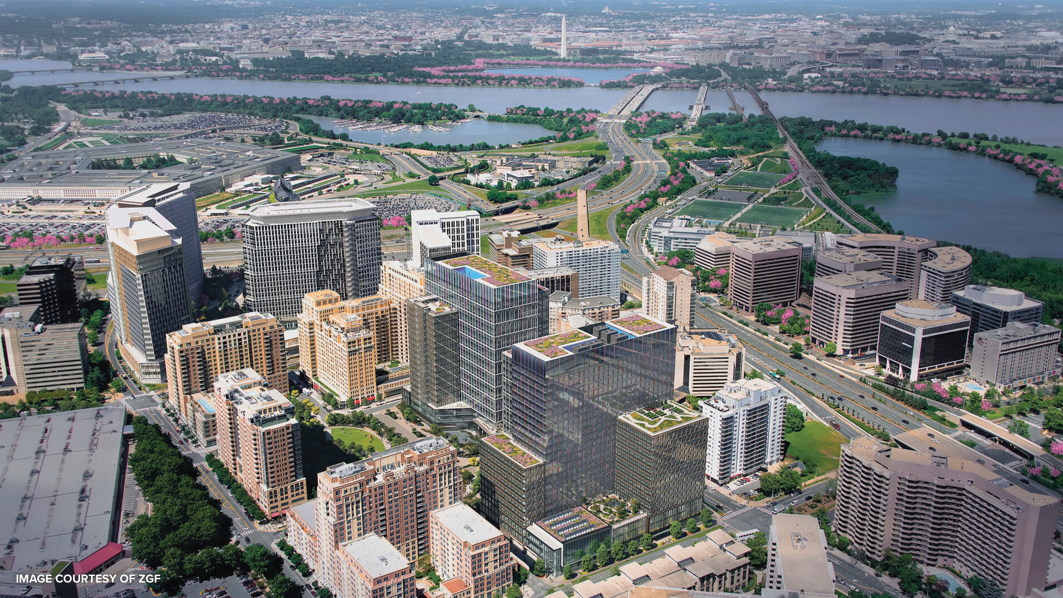
National Landing in Arlington, Virginia encompasses three major neighborhoods: Crystal City, Pentagon City, and Potomac Yard. The National Landing BID (Business Improvement District), located at the center of the DC region, invited RSM Design to craft a wayfinding and signage strategy and global wayfinding and experience trends to position the neighborhood as a world-class leader in innovation as a people-centric environment. The goal was to create a cohesive, “future-proof” design system that can be adapted by future neighborhood development through the implementation of smart technology in the three major neighborhoods to improve the pedestrian experience throughout.
In the context of 21st century America, how did you design a “pedestrian minded experience” for National Landing?
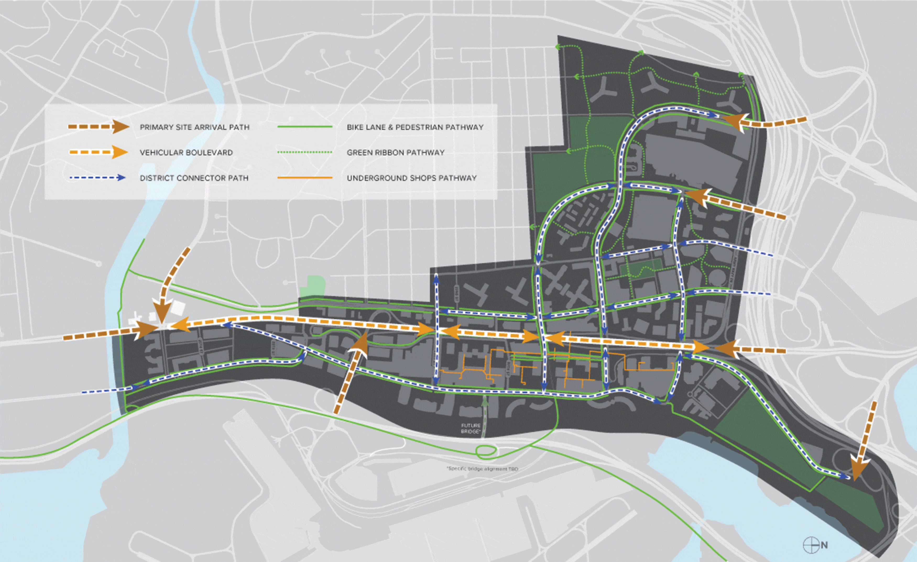
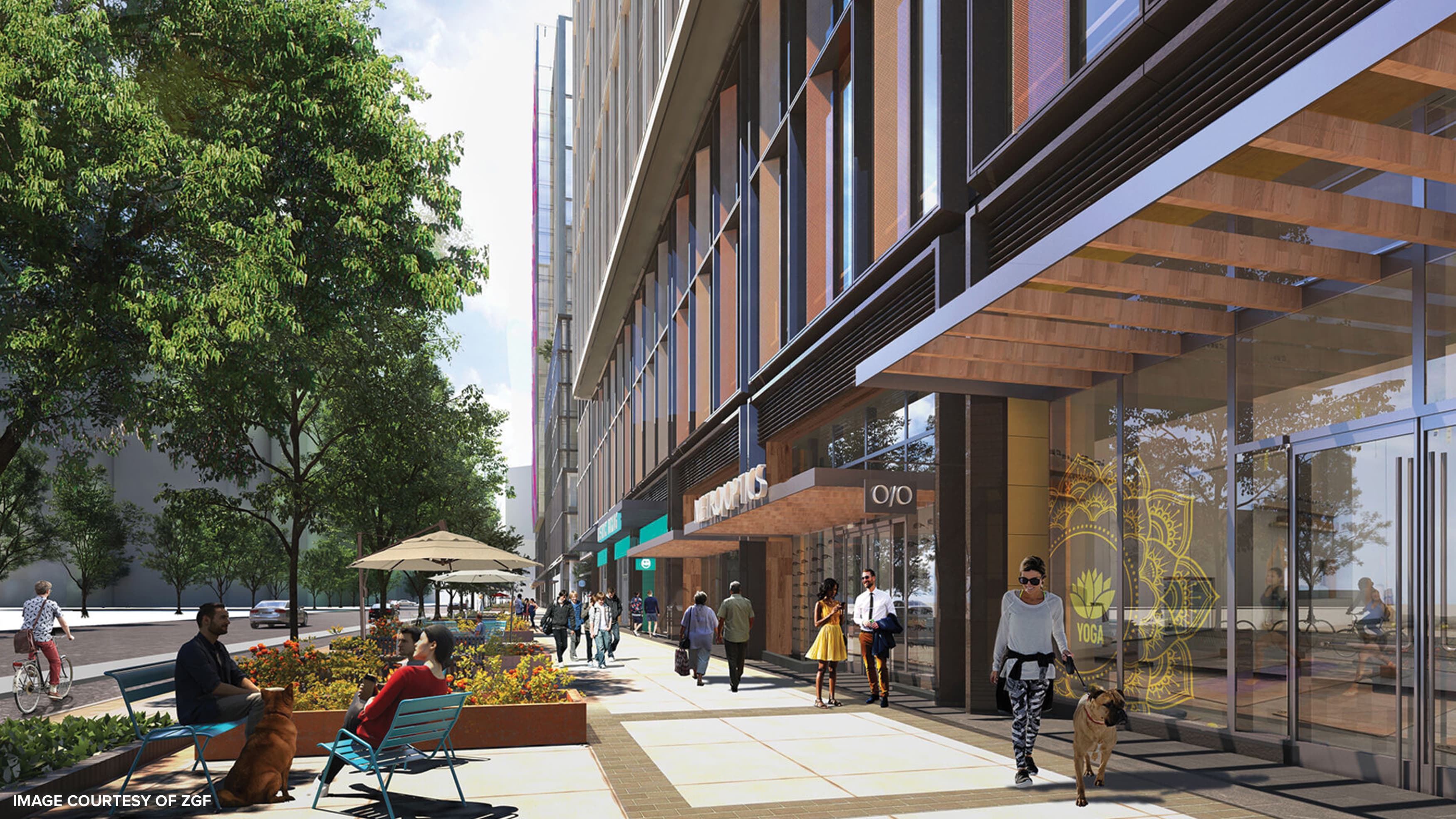
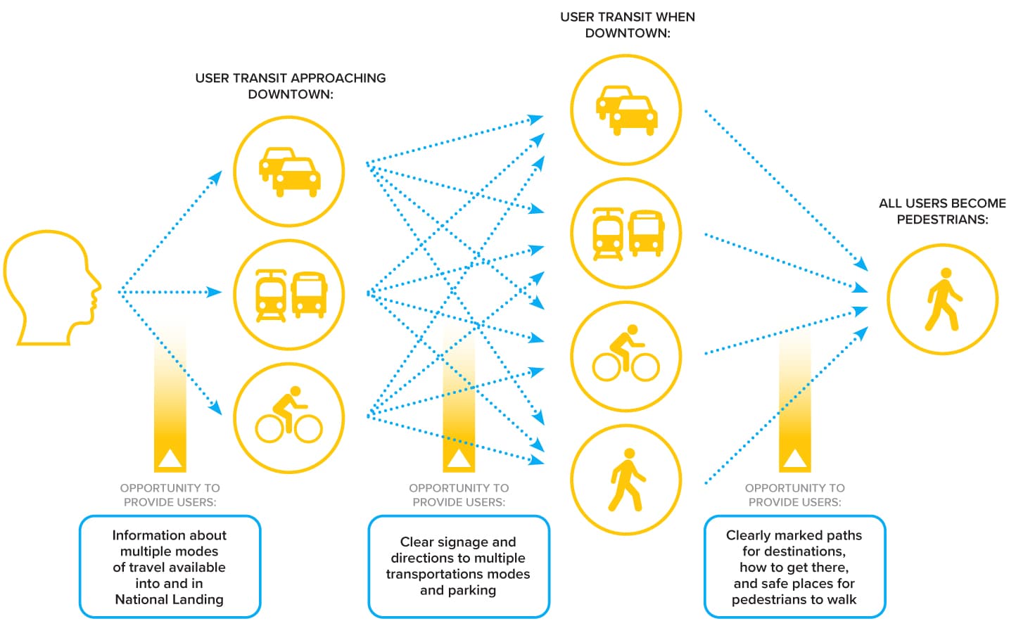
It was important that the National Landing BID leverage the density of the surrounding area while moving away from what had historically been uninviting, highly trafficked boulevards. We wanted to alleviate that by creating a consistent arrival experience that would help guests explore the three districts within National Landing without relying on the cars. We proposed a multi-layered approach, some of which is timeless in an architectural relationship with the landscape, such as sculptures to create landmarks that people want to visit that help them find their place within National Landing or more explicit physical wayfinding pieces at entry points and nodes. Other solutions are more reliant on current technology, handheld devices with apps designed to guide people using tools like maps, augmented reality and projection mapping compatible with the 5G technology in National Landing.
One of the things that we wanted to do was to bring the experience back to the individual so that the neighborhood can celebrate the pedestrian — something we learned by looking at Kevin Lynch’s approach to sensitive urban planning in The Image of the City, but with a 21st century spin. By offering easy movement throughout the neighborhood, this multi mobility network also invites visitors to feel free in investigating the unique details of National Landing. But this led us to ask: how do you facilitate the means by which people can meaningfully decipher the elements of their environment? How do you make them want to celebrate and discover their neighborhood rather than merely get from point A to B? We wanted commuters and tourists alike to become curious by inviting that element of discovery.
Can you elaborate on the trends studies you conducted to arrive at the final application of placemaking and wayfinding strategies for National Landing?
RSM developed a global trends benchmarking process that outlined innovative applications of wayfinding in urban, civic environments. Our process outlined key municipalities and public/private developments that are using commercially viable and experimental static and digital tools to layer into the physical environment. Our goal was to provide a wide range of tools that would support the key objectives. Our findings centered around market experience and how AI or personal devices might aid in transit, placemaking or education concerning the build environment.
What were your precedents for National Landing?
Downtown Santa Monica may have been one of them, but it was generally difficult to find parallels that dealt with a project of this large a scale. Because we were looking toward the future, the Walk NYC and Legible London projects became valuable case studies that we used quite a bit. We were looking for holistic approaches to a system that’s consistent from the bus stops to the train stops to those on the street directories and digital apps.. Also, older cities like Amsterdam that have a long history of integrating bike navigation informed a lot of our trend research.
When you brought up the the idea of “celebrating the pedestrian,” I was reminded that in America, the pedestrian has been more or less villainized the word “jaywalking” came into existence in the early 1920s to lay the blame on pedestrians for car accidents rather than the car owners as a means of privileging automobile access to the city. In National Landing, you are undoing a lot of the history of this relationship between pedestrians and car drivers in a uniquely American context.
They identified the presence of cars in the neighborhood as a real safety concern, as well as something that was limiting pedestrian access across the site. Another big piece of the pedestrian story is micro-mobility, including the bicycle experience and rentable scooters. These modes of transportation enhance the pedestrian experience by offering flexibility and the option to move at your pace, while reducing the need for cars. Planned improvements to bike lanes and sidewalks can be optimized with signage that creates safer environments and access to micro-mobility wayfinding hubs.
What technology might be initially unfamiliar to visitors to National Landing when they first arrive?
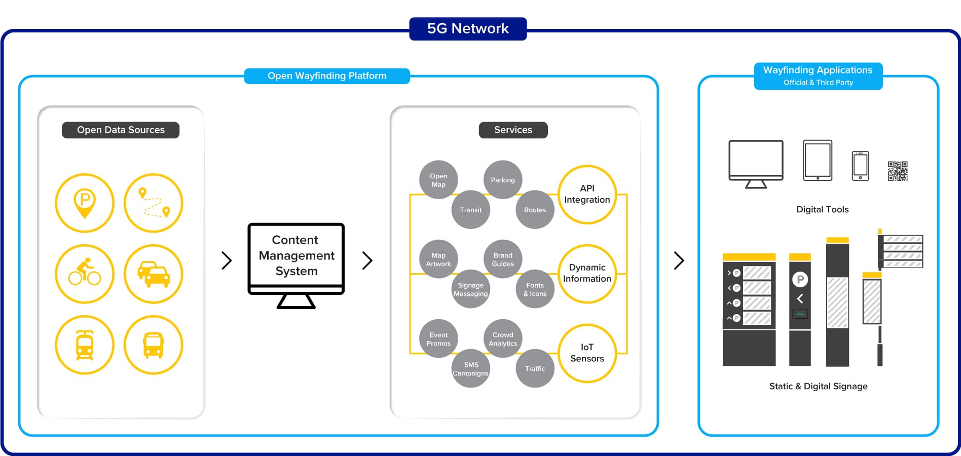
The idea of a truly dynamic wayfinding system is a new approach to an urban center like this. Based on the fluctuating needs and traffic conditions, we envision a system that can respond to best routes, parking availability and transit schedules. Visitors will no longer have to rely solely on static signage or be uninformed about potential hazards or delays. If the system is designed correctly, the learning curve for new technology should be fast and effortless, with messaging located exactly when and where you need it.
How do you feel that designing a wayfinding system for something as large and open-air as National Landing is different from that of vast interiors, such as airports or malls?
I think it’s a lot of the same principles, because in both, it’s about understanding where people need information and where they’re going. The solutions for offering safety and certainty are often the same because both provide opportunities for placemaking elements, such as sculptures, murals, and other kinds of landmarks that might speak to the community.
I would say that the experience of time is different between large interiors and neighborhoods: how people experience spaces and the duration of time. It does change how you design for people. The elements of National Landing, for instance, are things that people will be seeing every day. These will be places that people really love and have associations with already. In a neighborhood, you want wayfinding systems around only where they are needed. They should ultimately be experiencing their neighborhood, their architecture and parks, and their families more often than they interact with signs. And so I think that’s actually much more tangible, because in other contexts, such as an airport, visitors will have a relatively dissociated experience. In other environments, you have to turn up the volume and frequency of wayfinding systems.
Yes, in an airport, a mall or a subway system, there is often a more deliberate movement, and the signage is therefore expected to be crystal clear and omnipresent. How do the wayfinding systems you have designed for National Landing reflect the fact that it is not an interior, but rather a layered community?
The initial arrival and parking experience is more akin to that of going to the airport, but after making the transition from the garage to the street, the wayfinding systems are usually only there where needed to help people make a decision. That choice could be based on curiosity or it could be based on the easiest route to their destination. We look for ways of integrating with the existing downtown infrastructure, for instance, where there is a lot of pedestrian activity, in which we can integrate wayfinding systems into public kiosks or as part of a plaza area where people will be taking a little more time between finding their way to the next place.
It’s similar to the public parking branded system in Downtown Santa Monica. Anywhere you go downtown, there’s that icon, and that color. Even though they are owned by different parking operators, they are rebranded as one, and their exteriors are more or less pure sign systems. Then once you’re out, how many signs are there in the pedestrian areas? Not many. But you have them where you need them. The outdoor experience shouldn’t be like a mall, but it should be clear nonetheless.
What do you hope other cities might see in National Landing as an example of how the infrastructure of a city can provide ‘feedback’ to its users through smart technology?
One of the fundamental priorities of this project was to be responsive to accessibility concerns in every dimension imaginable. They wanted a system that would work for everyone: spanning those that are hearing and/or sight impaired, but also those that come to the neighborhood speaking different languages or users from varying socio-economic conditions. That goes back to the concept of ‘layered systems,’ where the full breadth of the system might include experiences that you have on your phone, but also digital hubs that can access the internet for those without phones, as well as Braille options, haptic feedback, and other technologies that could inform people outside of just a single app or even a single language. We considered a wide range of devices, which could include artificial intelligence software and digital kiosks that might predict what visitors are looking for and help them along like a neighborhood concierge that is both highly recognizable and approachable.
How might smart technology be used to increase the safety of an urban center?
One of the key needs identified was improving the wayfinding visual consistency and unifying the site. An exciting way that technology can help with this unification is through a digital “hand-off” between signage in the physical environment to your mobile device. This could create checkpoints for guests to confirm their route along the way, as well as integrate up-to-date information on changes or conditions, all in a consistent graphic language.
We researched a number of new apps and technologies that are improving safety. Important touchpoints in an environment like National Landing are crosswalks, bike lanes and accessibility for all visitors. For example, there are some amazing apps designed for the visually impaired that use 3D audio technology to describe your surroundings and set audio beacons that track your direction. At crosswalks, smart technologies are being developed that detect all road users, pedestrian and vehicular, with integrated safety notifications and AI algorithms that can predict the trajectory and speed of oncoming traffic. We were interested in tapping into advances being made in mobile robotics (such as MIT’s Spot project) to optimize National Landing’s 5G smart city infrastructure for capturing data and learning how and where to best assist people over time. Artificial intelligence can become a feedback loop that automates improvements in communication and public safety.
This model of urban wayfinding has the potential to undo the sense of modern alienation that has defined urban living since at least the end of the 19th century, in which urban residents feel as the city does not care about them, and that they have to operate within this unfeeling, unresponsive metropolis. Will this smart system act as a ‘friendly local’ that can guide pedestrians?
Yes, we want visitors to feel welcome as quickly as possible and feel as though there is nothing prohibiting them from exploring the area upon arrival.
It seems like what is taking place at National Landing could become a model for other American neighbors that are currently overly reliant on private automobiles for inner city transportation.
Absolutely. We were hoping to demonstrate to the residents of the Arlington and DC area that it is possible for an aging vehicular-centric downtown to be revitalized as a walkable city with multiple functions and a vitality that was not there before.
How do you see the placemaking and wayfinding applications gathered at National Landing as fitting within global benchmarks?
National Landing sees themselves as a global leader in creating liveable, connected and mobile communities. The key aspects of placemaking and wayfinding are contextual layers that only those elements can support. Our team seeks to stitch together these layers of brand, direction, education, art & culture, transit, commercial and entertainment to interconnect a community at all legible levels.